Tuesday, September 30, 2014

Stone Mountain


For my next adventure, I decided it was time to go back to Stone Mountain! I have been to Stone Mountain about 3 times in my entire lifetime, and considering I moved here from Texas when I was one year old, it was time to go back. Of those 3 times, I walked up Stone Mountain for the first time last summer. The other two times, I went with my family to Stone Mountain Village for the fireworks around the 4th of July and the other time for the laser show during the holidays. Both of which are great times to go by the way!

Walking Up Stone Mountain is free, you only have to pay for parking. Parking is $10 per day or you can purchase an annual pass for $35. I only had $15 on me so I had to buy the daily pass, otherwise the $35 pass would've been a great deal, especially since we plan to go again! The Walk-Up Trail is open from sunrise to sunset, I like working out in the morning, so we went around 10 AM. The Walk-Up Trail is about one mile and from the top, it is 1686 feet above sea level (Stone Mountain Park). The trail is marked by a yellow line so it is easy to remain on track and enjoy the views along the way. I loved the fact that there was plenty of shade for most of the hike (with the exception of the steep part of course). 

My brother David loves going to Stone Mountain so it seemed ideal to take him with me. Before embarking on our hike, he challenged me to not stop for a break until we reached the top. My brother and I are extremely competitive individuals. So being challenged helped me keep pushing even when the hike became difficult. Considering he is taller than me, it was challenging to keep up with his fast pace, but I pushed through. 

The first time I walked up Stone Mountain, I took a break by the picnic area and again right after the steepest part of the hike where the metal bars are located. This time around, it was tempting to take a break right after the steep part, but I pushed through! I wanted a picture of the steep part, but I decided to wait until we were on our way back down to snap a picture of him there. I am so glad I did, because I had a great sense of accomplishment when we reached the top without stopping! 


Together we made it!


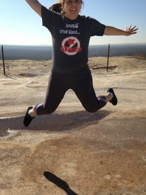
Making it to the top without stopping was challenging, but  worth the endorphin/adrenaline rush obtained from our hike up Stone Mountain! I was surprisingly full of energy when we made it, perhaps it was the adrenaline or sense of accomplishment, but I was filled with so much joy and energy that I wanted a picture in the air on top of Stone Mountain. 

When the energy started wearing off and the tiredness kicked in, it was finally time to take a break and enjoy the spectacular view from the top! It was so refreshing and relaxing to sit in silence and take in our view. Our view consisted of the Atlanta skyline and the North Georgia Mountains, and the surrounding Stone Mountain area. 
The top of the mountain's amenities include restrooms, water fountains, gift shops, and snacks.  

Something I learned from this hike: there are an additional 15 miles for hiking trails in Stone Mountain. We purchased the annual pass, so we will definitely have to go back and explore the remaining trails there! 

Friday, September 19, 2014

Vickery Creek Trail

And so the adventure begins... 

In search of a hiking trail for the first Amateur Hiking Adventure, I googled hiking trails with waterfalls in Georgia. I have never seen a waterfall before, therefore it seemed fitting to go hiking at a trail with a waterfall first! Through my search, I discovered three great sites that I will likely refer to in future adventures: Atlanta Trails, Georgia Trails, and Georgia State Parks. For this first adventure, I wanted to explore a hiking trail with a waterfall that is relatively close to me. Most of the trails that I found were about 1 hour to 2 hours north of Atlanta. Surprisingly, I found Vickery Creek Trail in Roswell, which is only about 15 miles from my house! Vickery Creek Trail is a 3 mile hike through the rolling forest and banks of Big Creek. The hike offers beautiful scenery from the old mills, to a covered bridge overlooking the Big Creek, fallen trees, and finally to the waterfall! 

My friend Berlin and I entered the Vickery Creek Trail through the Mill St. parking lot. Berlin said that she had been hiking at one of the nearby trails but had no idea there was a waterfall in this one particular hiking trail. Once we parked the car, we were ready to get started! The first thing we saw when we arrived to Vickery Creek was the pretty entrance that lead to a steep concrete incline. After going down the incline, we saw the historic Mills Ruins building. 


Entrance 
Mills Ruins


On the left side of the Mills Ruins was a long covered bridge over passing the Big Creek. From inside the bridge, visitors are able to take in the scenery of the Big Creek, the trees, and the trail up ahead. 

Inside of the covered bridge 

Past the the covered bridge, we found a flight of steep stairs that lead to the trail. The trail was too narrow to allow us to walk side by side for the majority of the hike. Which was fine since it allowed Berlin, the more experienced hiker to lead the way. I am not the most coordinated person out there, so having her lead the way was great for me to know what to be cautious about, what avoid, and upcoming terrain changes. 

The hike was moderately difficult, but not as difficult as I had first anticipated. Parts of the trail that felt more difficult to me as an amateur were the steep parts. However, it was totally tolerable and enjoyable! As my brother says "No pain, no gain". My two favorite aspects of the Vickery Creek hike was encountering the two fallen trees and the waterfall! 

Between two fallen trees
By the time we reached the waterfall, we were sweaty, tired, and ready for our snack. Fortunately, the waterfall was as great as I had anticipated! The waterfall was beautiful and the breeze was refreshing. It was the perfect place to take a break and eat our delicious, crunchy, fresh from the Farmer's Market peaches! Not sure if it was because we were hungry, but that peach was the best peach I've ever had.   


Amateur Mistakes:

The first rookie mistake I made was not giving myself ample time for hiking. I read that the trail itself is about 3 miles so I figured the most it could take would be 45 minutes to an hour so we went around 6:30 PM. For those who live in Georgia know that September's weather can be misleading in that it can be sunny and high in the 90s during the day and then suddenly rain in the evening. I for one, am not a big fan of the heat, so I thought hiking later in the day would be perfect. Unfortunately, I did not take into consideration the things that could go array on a first hiking adventure. Hiking at that time proved to be a mistake since we made wrong turns that only got us lost and before we knew it, it was dark and we still had not found our way back to the parking lot. 

Which leads to mistake number two: not reading the map properly. When we first arrived to the trail, I saw the map,  but since I saw that it practically looked like a loop, I figured "just go with the flow, eventually, we'll find the waterfall". NOT A GOOD IDEA! My plan was to loop around the entire trail, but simply making a wrong turn made us loop within the bigger loop of the trail. It seemed as if we had to make decisions between two or three paths, I would look at the map and choose the one I thought would be the correct path to take us back to the path we wanted to take. And more often than not, it turned out to be the wrong one. 

To add to the suspense of trying to find our way back to the parking lot in the dark, after being lost for a good 30 minutes, I was running low on water. Mistake number three: not taking enough water. I brought a small 20 oz water bottle. I tend to feel dehydrated rather quickly so I always carry water with me. Since it was dark, we were lost, and I was low on water, I became nervous. Luckily enough, we finally reached one of the marks we had previously reached and from there we found our way back! 

For future hiking adventures: go earlier, study the trail map ahead of time, take a bigger water bottle!  

Thursday, September 4, 2014

The Amateur

Hello fellow Amateurs (or Experts), 

Welcome to my blog! I'd like to start off by telling you a little bit about myself. My name is Elizabeth, I'm a 23 year old from Georgia about to graduate from college in a few months! As the title suggests, I am an amateur-hiker-wannabe but I am okay with it because I would like to become an experienced hiker someday and be able to travel and see what this beautiful mother earth has to offer! And what better way to start than in my own hometown? I have never hiked, in fact, the closest I have gotten to hiking has been walking Toby, my Husky-German Shepherd at the park. Therefore, when I say amateur, I really mean it (for now). This is also my first ever blog, so to say I'm excited for the next chapter in my life would be an understatement! For in a few months, I will be a college graduate, blogger, and (hopefully) a hiker!

   What you can expect from my Amateur Hiker Adventures:
  • Photos of the trails/interesting things I find along the way
  • Details of the trails
  • Lessons learned (mistakes made) 
  • I have never seen waterfalls and I've heard there are some in Georgia (whaaaaaaat?) so I aim to explore some of them! 
  • I have seen friends post photos from mountains and they always seem so beautiful, so I will also hike those! 
  • Fall is my absolute favorite season, so (spoiler alert) I will try to capture the changes in the coming months. 


"Exploring Georgia one hike at a time"